

About this record
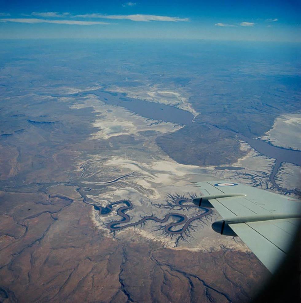
This colour photograph shows an aerial view of part of the Ord River in the east Kimberley region of northern Western Australia. The sinuous bends of the river and its floodplain, the site of the Ord River irrigation scheme, are clearly outlined beneath the wing of an aircraft. Mountain ranges on the left and at the bottom, and an incursion of higher ground on the right, surround the river's floodplain.
Educational value
- At 650 kilometres long and with a catchment area of about 55,000 square kilometres, the Ord is one of the major rivers of the Kimberley region of Western Australia. It rises near Halls Creek and today flows through the artificial water-storage areas of Lake Argyle and Lake Kununurra to empty into Cambridge Gulf. Its major tributaries are the Panton, Elvire, Nicholson, Negri, Wilson, Dunham, Forrest, Turner and Fox rivers.
- A series of meanders or bends such as those seen in the photograph often occur in the middle or mature stages of a river and, in the case of the Ord River in 1970, were at their most sinuous about 60 kilometres from the sea. Some meanders in the Ord were formed as the river flowed around obstacles, but most were created by the lateral erosion of their outer banks to form river cliffs and the deposition of the eroded material on the inner banks (slip-off slopes) opposite.
- The Ord River is the site of one of Australia's most ambitious irrigation schemes and by the time this photograph was taken, the project was well under way. First conceived in the early 1940s, the project's viability was assessed by a joint federal and state research station from 1945 onwards, and by 1958 the Western Australian Government was ready to go ahead. By 1967 the Kununurra Diversion Dam had been completed and the first irrigated farm sites allocated.
- In 1970 the Kununurra Diversion Dam provided water for irrigation, but an even larger dam, the Ord River Dam, was being built. This dam created Lake Argyle, with a capacity of 31 billion litres. Lake Argyle stores wet-season water flows and releases them at regular intervals into the diversion dam, generating hydro-electricity. The diversion dam continues to provide farms with water for irrigation, but most of it is released into the Lower Ord.
- At the time of the photograph, although somewhat altered by the irrigation scheme, the Ord River's flow was still fairly seasonal. During the dry season there was little or no flow and water was confined to pools; during the wet season from November to April, the river flowed strongly. Since the establishment of Lake Argyle however, the water levels have been fairly constant and the Lower Ord now flows continually, with major environmental consequences.
- While proponents of the Ord River irrigation scheme were claiming success in 1970, serious problems were already evident. The main crop was cotton, although some safflower and rice were also grown, and growers in the area were becoming increasingly reliant on pesticides to control insects such as the larvae of the heliothis moth. The insect population quickly became resistant to pesticides and by 1974 growing cotton was no longer viable.
Acknowledgments
Learning resource text © Education Services Australia Limited and the National Archives of Australia 2010.
Related themes
Need help with your research?
Learn how to interpret primary sources, use our collection and more.


